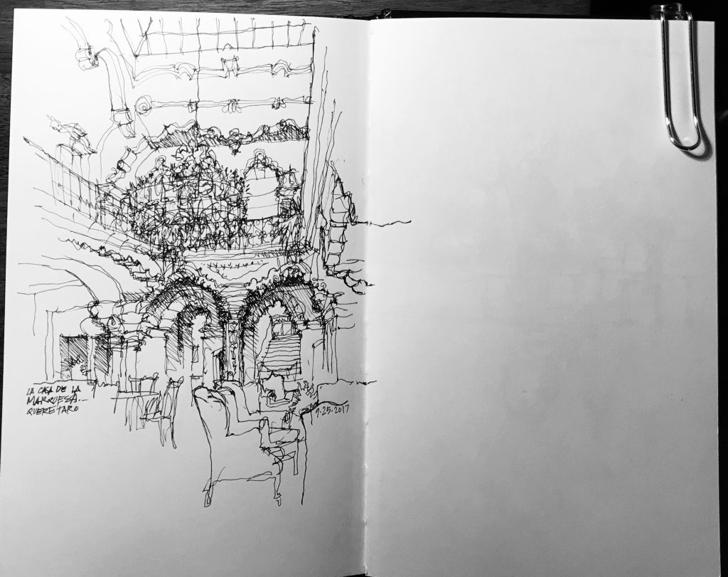
Beacon Hill

The Seattle Urban Sketchers met recently at the Beacon Hill station, one of the stops in Sound Transit’s Metro’s Light Rail system, between the SODO and Mount Baker stations. Probably because of site and space constraints, there are no escalators to access the train platforms below grade. Rather, the doorways you see here are actually elevator entrances down to the train level.

This second sketch is of the entrance to El Centro de la Raza—the cultural, educational, and social service agency founded in 1972 by Chicano activists who occupied the then vacant Beacon Hill Elementary School. Note the banner declaring the school, as any other school, is a “Sensitive Location.” This refers to the U.S. Immigration and Customs Enforcement (ICE) policy regarding where it can enforce its enforcement actions. To quote from the ICE website: “ Pursuant to ICE policy, enforcement actions are not to occur at or be focused on sensitive locations, such as schools (and) places of worship…”

Winslow, Washington

To make up for the unfortunate cancellation of the annual West Coast Sketch Crawl in Vancouver, BC, the Seattle Urban Sketchers scheduled a series of get-togethers the weekend of August 11–13. One of these was to the town of Winslow on Bainbridge Island. The first sketch above was a quick view of downtown Seattle from the ferry on its way to Bainbridge Island.

This is the Bainbridge Island Museum of Art, designed by Coates Besign Architects, which opened in 2013 as a welcoming sight as one leaves the ferry terminal for downtown Winslow.

The final view is of Harbor Marina in Eagle Harbor, just west of downtown Winslow.

Wright Brothers Cycle Works

I’ve always admired the rickshaw standing out in front of the Wright Brothers Cycle Works at 219 North 36th Street in Fremont. Established by Charles Hadrann in 1974, the shop is a full-service repair facility for various types of bikes, including those for cyclocross racing and randonneuring. The shop also offers classes in general bike maintenance and functions as a co-op, providing the use of tools and space to do your own repairs.

The above images show the difficulty I had in getting the proportions and foreshortening right. Sometimes, things just don’t work out as you expect them to.

Seattle Tower


The Seattle Tower is a 27-story high-rise located at 1218 Third Avenue. Originally known as the Northern Life Tower when it was completed in 1929, the Art-Deco building was designed by Abraham H. Albertson in association with Joseph W. Wilson and Paul D. Richardson. Although not as tall as the Smith Tower, it rose one floor above “the tallest building west of the Mississippi” because it is situated at a higher elevation. A subtle design feature are the 33 shades of brick that progressively lighten as the structure rises from its base on Third Avenue.

The Seattle Tower is now dwarfed by newer, taller skyscrapers but it retains its elegant and distinctive Art-Deco roots. It is City of Seattle Landmark number 137 and was listed on the National Register of Historic Places in 1975.

This last view if of the main elevator lobby, looking toward the entrance doors.

Pike Place MarketFront

MarketFront is the first expansion of Pike Place Market in 40 years. The mixed-use development, designed by the Miller Hull Partnership, consists of a public plaza offering views of Puget Sound and the Olympic Mountains; day stalls for farmers, artists, and artisans; restaurant and retail spaces; as well as a community center and low-income, senior housing units. The first view above is looking up at the multilevel design as it steps down the hill toward the waterfront.

This second view is from the public viewing platform, looking down toward Elliott Bay and beyond.

Chapel of St. Ignatius

This past week, I joined Seattle Urban Sketchers Gail Wong and Stephanie Bower, along with Ch’ng Kiah Kiean visiting from Malaysia, to sketch the Chapel of St. Ignatius on the Seattle University campus. The tiny chapel, designed by Steven Holl Architects in association with Olson Sundberg Architects, was completed in 1997 as the spiritual center of the campus.

After I quick exterior view, I moved inside to do a couple of line drawings, which are not quite capable of capturing the way daylighting is reflected off of the various textured and curved interior surfaces. The last drawing I did used hatching to try to capture the tonal values of the space. This chapel interior is an example of where a watercolor sketch might better suit the subject matter.

465 North 36th Street

Searching for a scene to draw on a beautiful, sunny 75° day, I remembered this house and its side yard, which I’ve walked by numerous times. As so often happens, what I initially envisioned drawing—the side yard space—ended up being edited out, with the focus shifting to the house structure itself, built over a century ago, in 1901, and now housing a women’s clothing and jewelry store.

Salmon Bay Sand & Gravel Company

A familiar sight for anyone driving along Shilshole Avenue Northwest on the way to Golden Gardens Park is this Salmon Bay Sand & Gravel Company complex. The company is a supplier of sand, gravel, and ready-mixed concrete, as well as tools for the concrete, plaster, stucco, and masonry trades.

Samuel Nerdrum founded the company in 1907 on the shores of Salmon Bay, prior to Seattle annexing the then City of Ballard and ten years before the construction of the Ship Canal and the Ballard Locks. One of the company’s first jobs was to offload barges of sand and gravel that entered Salmon Bay at high tide and transfer the material to horse-drawn wagons, which then carried the materials to the Alaska Yukon Exposition site, where the University of Washington campus is now located.

A Centennial Celebration

In remembrance of the centennial anniversary of the official opening of the Fremont Bridge on June 15, 1917, and that of the Lake Washington Ship Canal and Hiram M. Chittenden Locks (aka the Ballard Locks) nineteen days later, on July 4, 1917, I am reposting several drawings of the Fremont and Montlake Bridges that cross the Ship Canal.

For a brief history of the Lake Washington Ship Canal and the Hiram M. Chittenden Locks, please see <http://makingthecut100.org/lwsc-and-the-locks/>. For a history of the Fremont Bridge, see <http://historylink.org/File/20374>.

An Alley View

The Seattle Urban Sketchers group met at the Lenin stature in the Fremont neighborhood this past Sunday morning. Despite the, for Seattle, hot sun and extremely warm temperature, I managed to find a shady spot from which to draw this view along the alley between North 35th and North 36th Streets.

Alleys are interesting places. In addition to serving as conduits for goods and services, they provide more intimate views of the back sides of buildings and other structures, which we mostly see from their more public fronts.

If you look closely, you will notice the stray lines that indicate my several attempts to get the building forms in proper proportion, relative to the width of the view. It’s important to realize that it is extremely difficult to execute a drawing without any of these stray lines unless one draws first in pencil before inking over and erasing the pencil lines. I prefer using only ink and letting the process of building a drawing show through.