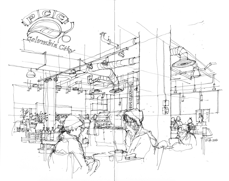
Upper Queen Anne Hill

On what turned out to be a beautiful Sunday morning after a few cloudy, showery days, the Seattle Urban Sketchers group met in the upper Queen Anne neighborhood just north of downtown. As I was viewing the subject of my first sketch, Nana’s Mexican Family Restaurant, I realized that the scene presented a multitude of details that would overwhelm the eye. I therefore chose to draw very selectively, leaving a lot of white space for the imagination to fill. This approach required the selection of a dominant element—in this case, the sign above the sidewalk—and then proceeding so that the drawing would lead the eye from one area of interest to the next. The key is never to lead the eye off the page.

I used a similar approach for the remaining two drawings I was able to do during the morning session.

Pioneer Square Scenes

The first drawing is of an elegant art deco facade added in 1929 to unify and conceal two separate buildings that were built around 1900. The original drawings in the City of Seattle Department of Planning and Development are unsigned but the client was Rautman Plumbing and Heating Company.

In contrast to the contextual view above, this drawing is simply of a trolley stop at the Occidental Park terminus of the now defunct George Benson Waterfront Streetcar line that operated from 1982 to 2005. The popular tourist attraction used five 1924-era streetcars imported from Melbourne, Australia.

The third sketch is of the memorial to Seattle’s fallen firefighters in Occidental Park. While the artist Hai Ying Wu was inspired by the four firefighters that died while fighting a warehouse fire in Seattle’s Chinatown International District on January 5th, 1995, the sculptures are a tribute to all of the firefighters that have fallen in the line of duty since the department began in 1889. Surrounding the figures are slabs of granite intended to depict a collapsed building.

Fremont Siphon Replacement Project

Just south of where NW 36th Street bends and turns into Leary Way NW there is a large construction site. It is difficult to see what is going on there because most of the activity is occurring underground but we do know that two new 500-foot long microtunnels have recently been installed to replace the existing siphon that runs under the Ship Canal between the Fremont and Queen Anne neighborhoods.

The existing siphon is almost 100 years old and at the end of its service life. It’s amazing to realize that the two large cast iron pipes that make up the siphon can carry up to 220 million gallons of sewage and stormwater per day from a 100-square-mile service area covering a large portion of north Seattle and even parts of north King and Snohomish counties. From the Queen Anne side of the siphon, a single large pipe delivers the charge to the West Point Treatment Plant in Discovery Park.

The remaining work now consists of connecting the existing sewer line to the new siphons via a 9-foot diameter pipe and the construction of an odor-control facility.

Still More Tacoma Sketches

To conclude my posting of sketches that I did during the 4th Annual West Coast Urban Sketchers Sketch Crawl in Tacoma, here are a couple more from Sunday morning’s session. The temperature drop from the heat of the previous two days was invigorating. What attracted me to these two views was the way the paths bifurcated (split into two branches or forks). The first is where Prairie Line Trail splits off from Pacific Avenue in front of the Tacoma Art Museum. The second is further up along the Prairie Line Trail on the UW Tacoma campus where it merges with Dolly Roberson Lane.

More Tacoma Sketches

Here are a couple more sketches from the 4th Annual West Coast Urban Sketchers Sketch Crawl. Saturday afternoon I ventured to the Theater District where I captured this view of Old City Hall, designed by E.A. Heatherton and built in 1893. The Italianate structure features a ten-story clocktower that establishes the focus for the composition.

The second view is of Tacoma’s version of the Spanish Steps that links Commerce Street and South Broadway. Adjacent to the stairway is the Tacoma Elks Lodge. Interestingly, after drawing these two views, I discovered that McMenamins—the Pacific Northwest enterprise of pubs, historic hotels, and concert venues— is currently rehabilitating the Elks Lodge and has a tentative agreement to lease and then purchase the Old City Hall, the intent being to form a hotel, restaurant, and entertainment complex in the heart of downtown Tacoma.

.

4th Annual West Coast Urban Sketchers Sketch Crawl

Photo courtesy of Kate Buike

Photo courtesy of Kate Buike

Enjoyed the camaraderie and having some free time to sketch at the 4th Annual West Coast Urban Sketchers Sketch Crawl in Tacoma this past weekend. Thanks to Frances, Kate, Darsie, Mark, and the rest of the Tacoma Urban Sketchers organizing committee for all their hard work in organizing and hosting the event, and making sure everyone enjoyed themselves and everything ran smoothly. Here are a few of the drawings I managed to do in the Museum District Saturday morning.


Hope to see everyone again next year in Vancouver, BC.

Ballard Mini-Pod

BallardMiniPod

I’m continuing to experiment using the Apple Pencil with the Procreate app on my iPad Pro. Here is a view of the Ballard Mini-Pod, a triangular site at 17th Avenue NW and NW 54th Street comprising Garden Sushi, Tripod Coffee, and a rotating series of mobile food trucks. Another realization I came to in doing this sketch is the tiny but perceptible separation I felt between the tip of the stylus and the lines being drawn through the glass. A couple of readers have suggested using a screen protector to better mimic the feel of paper but I’m afraid the extra layer of protection might only increase that sense of separation I feel.

As I mentioned in my last post, I like the ability to export as a movie any drawing or painting created in the Procreate app. Here is a video of the drawing above.

Drawing with the Apple Pencil

When I purchased my first iPad 5 years ago, I was excited to try out various drawing apps designed for the digital tablet. Disappointed with the lag time and feel of the styli available at the time, I resorted to drawing with my finger instead. At first, it was liberating to sketch so loosely but I soon returned to drawing with a fountain pen on real paper. I missed the feel of a metal nib flowing liquid ink onto a paper surface.

Hearing about the new Apple Pencil, I decided to try it out with the Procreate app. Here are a few examples.

I found that while the Apple Pencil had less lag and better “feel” than other styli I have tired, there was no doubt that I was drawing on a glass surface. Also, while the iPad has good palm rejection technology, I still inadvertently touched certain menus and options while drawing in the Procreate app, causing unintentional effects to occur randomly. Even so, realizing that I am not using all of the drawing app’s capabilities, I’m resolved to continue to experiment with the new media.

Pier 86 Grain Terminal

I missed the last meeting of the Seattle UrbanSketchers group at Centennial Park and so I ventured there myself to draw this view of the Pier 86 Grain Terminal. The Port of Seattle built this grain terminal in 1970 to replace the Hanford Street Terminal and satisfy the need for a larger facility as grain exports from the Northwest grew. A completely automated process moves grain from trucks and railroad cars to storage silos and from there, two 48-inch conveyor belts load the grain onto cargo ships at a maximum rate of 3000 tons per hour. The facility sits along and over the pedestrian and bike paths of Centennial Park on Elliott Bay and frames a view of downtown Seattle beyond.

This is a similar view of the grain terminal from 2014.

Center of the Universe

I’m updating an entry I posted a couple of years ago regarding what Fremont likes to call itself: “The Center of the Universe.” Here are two views of the literal center of the Center, the intersection where Fremont Avenue North, North 35th Street, and Fremont Place North all meet. The first is looking northwest toward Fremont Place North and Fremont Avenue North.

This second drawing is from a cold day in January 2014, looking northeast at the same intersection. On the traffic island, you can see a post with directional markers pointing to places both near and fa