Seattle Tower


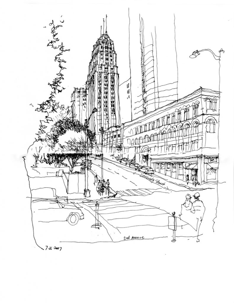
The Seattle Tower is a 27-story high-rise located at 1218 Third Avenue. Originally known as the Northern Life Tower when it was completed in 1929, the Art-Deco building was designed by Abraham H. Albertson in association with Joseph W. Wilson and Paul D. Richardson. Although not as tall as the Smith Tower, it rose one floor above “the tallest building west of the Mississippi” because it is situated at a higher elevation. A subtle design feature are the 33 shades of brick that progressively lighten as the structure rises from its base on Third Avenue.

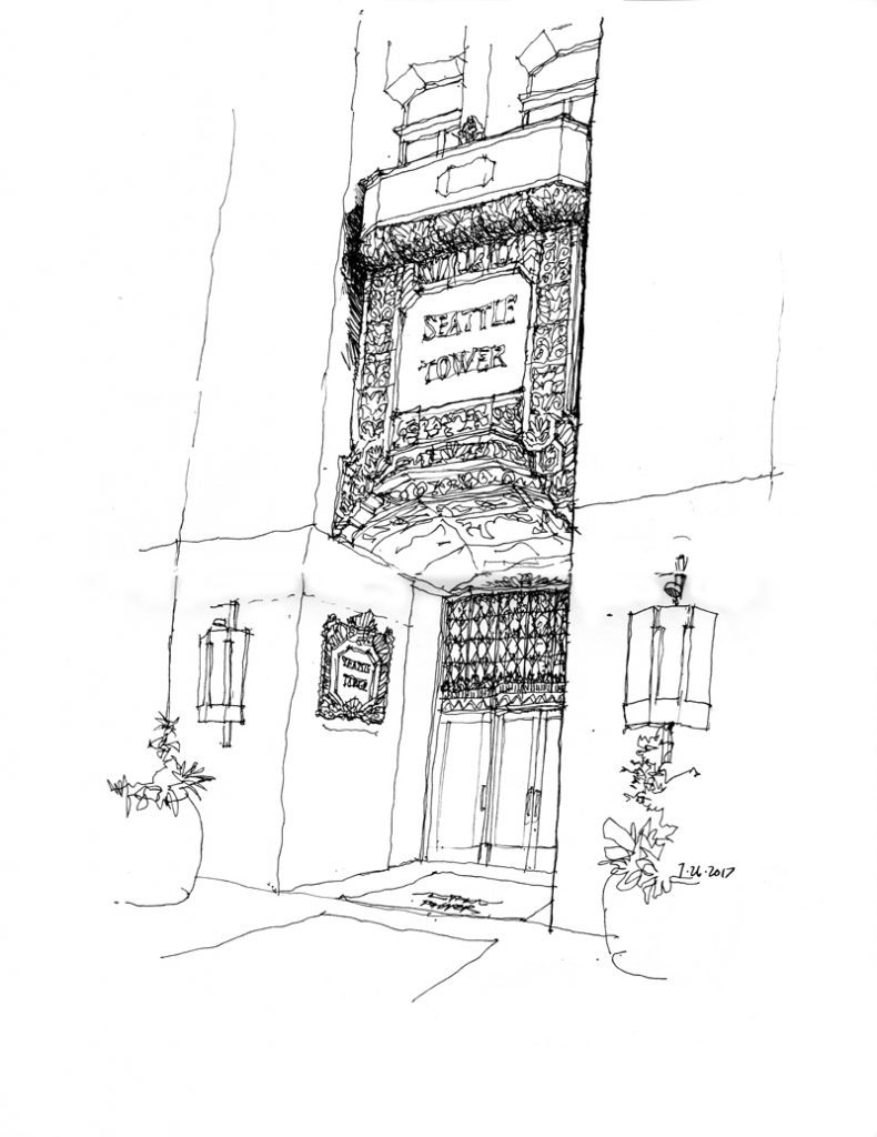
The Seattle Tower is now dwarfed by newer, taller skyscrapers but it retains its elegant and distinctive Art-Deco roots. It is City of Seattle Landmark number 137 and was listed on the National Register of Historic Places in 1975.

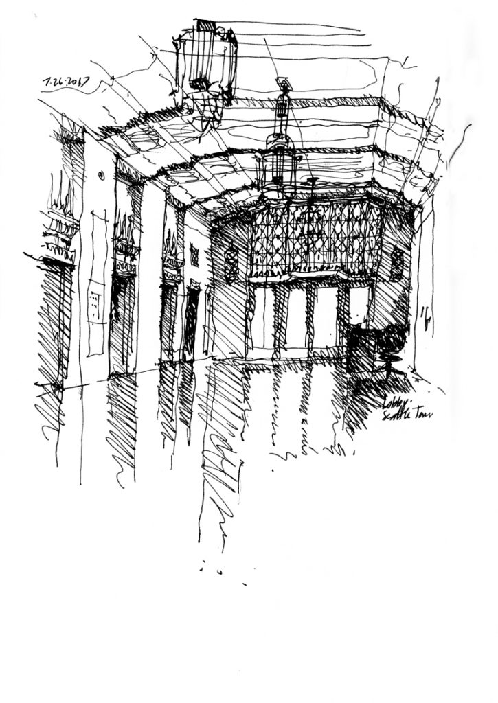
This last view if of the main elevator lobby, looking toward the entrance doors.

Pike Place MarketFront

MarketFront is the first expansion of Pike Place Market in 40 years. The mixed-use development, designed by the Miller Hull Partnership, consists of a public plaza offering views of Puget Sound and the Olympic Mountains; day stalls for farmers, artists, and artisans; restaurant and retail spaces; as well as a community center and low-income, senior housing units. The first view above is looking up at the multilevel design as it steps down the hill toward the waterfront.

This second view is from the public viewing platform, looking down toward Elliott Bay and beyond.

Chapel of St. Ignatius

This past week, I joined Seattle Urban Sketchers Gail Wong and Stephanie Bower, along with Ch’ng Kiah Kiean visiting from Malaysia, to sketch the Chapel of St. Ignatius on the Seattle University campus. The tiny chapel, designed by Steven Holl Architects in association with Olson Sundberg Architects, was completed in 1997 as the spiritual center of the campus.

After I quick exterior view, I moved inside to do a couple of line drawings, which are not quite capable of capturing the way daylighting is reflected off of the various textured and curved interior surfaces. The last drawing I did used hatching to try to capture the tonal values of the space. This chapel interior is an example of where a watercolor sketch might better suit the subject matter.

465 North 36th Street

Searching for a scene to draw on a beautiful, sunny 75° day, I remembered this house and its side yard, which I’ve walked by numerous times. As so often happens, what I initially envisioned drawing—the side yard space—ended up being edited out, with the focus shifting to the house structure itself, built over a century ago, in 1901, and now housing a women’s clothing and jewelry store.

Salmon Bay Sand & Gravel Company

A familiar sight for anyone driving along Shilshole Avenue Northwest on the way to Golden Gardens Park is this Salmon Bay Sand & Gravel Company complex. The company is a supplier of sand, gravel, and ready-mixed concrete, as well as tools for the concrete, plaster, stucco, and masonry trades.

Samuel Nerdrum founded the company in 1907 on the shores of Salmon Bay, prior to Seattle annexing the then City of Ballard and ten years before the construction of the Ship Canal and the Ballard Locks. One of the company’s first jobs was to offload barges of sand and gravel that entered Salmon Bay at high tide and transfer the material to horse-drawn wagons, which then carried the materials to the Alaska Yukon Exposition site, where the University of Washington campus is now located.

A Centennial Celebration

In remembrance of the centennial anniversary of the official opening of the Fremont Bridge on June 15, 1917, and that of the Lake Washington Ship Canal and Hiram M. Chittenden Locks (aka the Ballard Locks) nineteen days later, on July 4, 1917, I am reposting several drawings of the Fremont and Montlake Bridges that cross the Ship Canal.

For a brief history of the Lake Washington Ship Canal and the Hiram M. Chittenden Locks, please see <http://makingthecut100.org/lwsc-and-the-locks/>. For a history of the Fremont Bridge, see <http://historylink.org/File/20374>.

An Alley View

The Seattle Urban Sketchers group met at the Lenin stature in the Fremont neighborhood this past Sunday morning. Despite the, for Seattle, hot sun and extremely warm temperature, I managed to find a shady spot from which to draw this view along the alley between North 35th and North 36th Streets.

Alleys are interesting places. In addition to serving as conduits for goods and services, they provide more intimate views of the back sides of buildings and other structures, which we mostly see from their more public fronts.

If you look closely, you will notice the stray lines that indicate my several attempts to get the building forms in proper proportion, relative to the width of the view. It’s important to realize that it is extremely difficult to execute a drawing without any of these stray lines unless one draws first in pencil before inking over and erasing the pencil lines. I prefer using only ink and letting the process of building a drawing show through.

Place du Grand 9 Avril 1947

This is a view of Place du Grand 9 Avril 1947, also known as Grand Socco (Big Square), just outside one of the gates to the médina of Tangier. The square is named after the speech Mohmamed V gave in support of Moroccan independence on April 9, 1947. Normally the space is filled with street performers and vendors selling a variety of fruits, spices, and second-hand goods but it was somewhat quiet due to the beginning of the observance of Ramadan—the annual holy month of praying and fasting for Muslims worldwide

Médina Pathways

The Médina of Fès is one of the largest car-free urban zones in the world and through its pathways people and goods flow like the blood coursing through our arteries and veins. Because of their narrowness, it seems awkward to call these pathways “streets” although that is how they function. In addition to serving as paths for people and conduits for goods carried by handcart or donkey, these “streets” serve as informal social spaces and as extensions of small commercial establishments.

There are generally three scales, ranging from main streets as seen in the first image above, to side streets, and finally to back streets as narrow as a meter wide as seen in the images below.

Matters of Scale

This post is not about drawing. Rather, it concerns the issue of scale—the relative sizes of things and how we perceive this comparison—which is relevant to both drawing and design.

The historic core of the Médina of Fès, Fes el Bali, was founded in the late 9th century as the capital of the Idrisid Dynasty. The médina is full of souks and artisans working in leather, copper, brass, wood, textiles, and ceramics, and is home to historic mosques, mausoleums, and madrasas, as well as Al-Karaouine, founded in 859 and considered to be the oldest continuously operating university in the world. Markets line its car-free streets and sell all manner of herbs, spices, fruits, and vegetables. Declared a UNESCO World Heritage Site in 1981, the Médina of Fès remains to this day a medieval town in layout and scale, with a dense, low-rise building fabric, and narrow streets.

Returning home to Seattle from Fès, I find it difficult to convey the differences in scale and density of the two urban environments. Above, I overlaid (I hope accurately) the plan of the Médina of Fès atop a map of a portion of Seattle to indicate their relative sizes. What cannot be seen, however, are the relative population densities of the two urban areas. That of Seattle is around 6,800/square mile while that of the Médina is roughy 70,000/square mile. Even if my calculations are off by a little, that is a significant difference in scale that is difficult to understand without actually experiencing it.